There was a slight chance of freezing rain when we went to sleep.
Today we were planning to head to Big Bend Texas but when we woke up this morning we found that the 20% chance of freezing rain had occurred and exceeded expectations. So we decided to take our time moving out and instead visit Fredericksburg Texas. Fredericksburg is in an area of the Texas Hill Country settled by Germans in the 1860’s. It is a cute little town commercializing its German heritage. It is the childhood home of Chester Nimitz who is probably one of the most underrated American military commanders in history. His father and grandfather were prominent citizens of Fredericksburg owning the main hotel in town. After the war the town decided to construct a museum to honor Nimitz. The Pacific War Museum is a very impressive museum documenting the war from its origins to post war recovery. If you are anywhere near Fredericksburg I highly recommend it.
The Nimitz house at the Pacific War Museum.
It seems that it is a tradition to name your Tiger so we have been waiting for some inspiration for a name. Today Ton came up with the name for our Tiger it is Scout. This is how she came up with it, Tiger in Thai is Seua (may not be the official transliteration), our Tiger is small so it is a young Tiger, Leuk Seua in Thai, Leuk Seua is also the Thai name for the Boy Scouts which brings us to Scout, and since a Scout is someone who explores our Tiger is Scout. The original plan was to drive without using the interstates, but we are running out of time so it looks like tomorrow we will be heading Southwest on I-10 to Big Bend National Park.
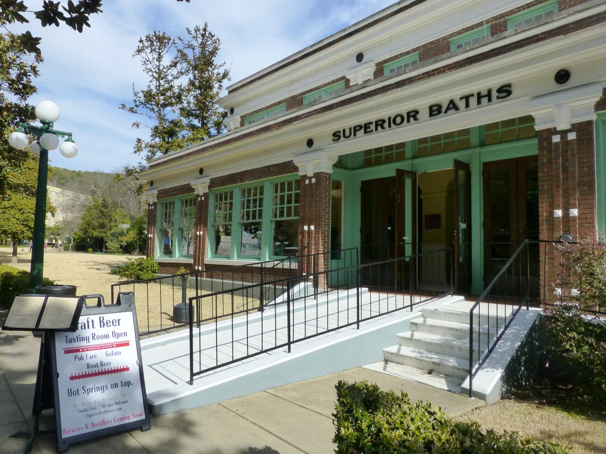
Today we left Little Rock and began heading South West towards Big Bend National Park. Our first stop was to visit Hot Springs National Park. It is a different type of National Park as it is set around a bunch of 19th century bath houses. Hot Springs Arkansas has over 40 natural hot springs. In the 19th century the Hot Springs were developed as a place to take the waters, much like the famous Spas in Europe. Over time the springs were recognized as a national asset and the government became involved. This has led to claims that it is the first National Park, however it was not designated as a national park until much later and is in fact the 17th National Park.
One of the bath houses at Hot Springs NP.
After the visit to the Hot Springs we decided to head towards Texarkana Texas. We decided to take the back roads as we really want to see the US from the smaller roads, we want to experience the small towns of our states and try to get to see the country on a more intimate scale. Today we came up behind an Arkansas State Trooper near Camden Arkansas. He was following another vehicle who was running below the speed limit. He pulled over to the shoulder and allowed us to pass. He then pulled up behind us with his lights on and stopped us. I was not completely surprised, the Tiger is a unique vehicle, and our South Carolina Temporary plates are worst for the wear as a result of the two monsoons we went thru earlier. Initially I produced my license and proof of insurance as well as the temporary registration South Carolina provides. He asked me to step back to his car with him so I could answer any questions he might have. Back there initially the questioning was standard, where were we going, where did we come from he wanted a great deal of detail on our itinerary. Then the weird questions started, did we have any drugs, guns or large sum of money. At first I thought he was kind of joking around, but when I realized he was serious my tone changed. At that point he said that from his training my answers indicated I was being untruthful. This he said was a Red Flag, he also said that a RV like ours traveling on the backroads was a Red Flag. At that point he said to wait there and he went and questioned Ton. Later I learned he put her through the same questions. He then returned to me and said that Tons itinerary did not agree with mine and he believed we were concealing something in the Tiger. At this point I could see where this was going so I offered to have him search the vehicle. At this point he frisked me and moved me to the front of the Tiger and moved Ton to the rear near the patrol car and told her to stand in front of the camera in front of his patrol unit. At this point he searched the vehicle concentrating on the front of the truck and the engine compartment. After spending about 45 minutes going through the vehicle and looking over the outside, he came to the cabin door which was locked. I told him the key was on the key ring in the ignition. At that point he came to me and said that he was going to let us go, even though he had not finished searching the truck. At this point while unsettling I was only mildly annoyed and chalked up the encounter to a young State Trooper on a slow Sunday afternoon in rural Arkansas. But then the guy really frosted me when he ended the encounter by saying that though he did not find anything he was still convinced that we were carrying contraband and were being untruthful with him. I offered to let him continue to search the vehicle until he was content, but he declined.
When we were thinking about buying the Tiger we read many blogs about encounters with the police some unpleasant and most routine. So despite driving a brand new RV, and despite the record check on both of us coming up clean we were subjected to a full search of our vehicle, and left with the final comment from the only representative of Arkansas we ever came across that he expected we were running drugs despite his inability to find any after a thorough search of our RV. I never expected to have it happen here in the US. The funny thing is just a few minutes before the stop we were talking about how Arkansas had been a pleasant surprise and that we may need to return to explore the Ozarks in detail. Now we will never return.
The moral of the story is if you are driving a RV in Arkansas, do not leave the interstate as it is a Red Flag to the State Police, insure that you and your spouse can recite your previous 20 days destinations in detail both as to location and chronology or it will be a Red Flag to State Police, and make sure that when encountering the Arkansas State Police that you answer all questions promptly and with the same tone of voice or that may be a Red Flag.
Let me end today with a picture of the beautiful sunset we enjoyed in Texas.
Today we are back on the road. The week in Elizabethtown was incredibly cold with overnight lows near 0 every night. When we arrived I thought about bleeding the water out of the truck and putting in anti-freeze, but figuring we were in Kentucky I thought it would have to warm up, I was wrong. We really tested the Webasco Heater, and solar system in extreme conditions and they came thru well. We were able to keep the heater going for 6 days with below freezing temperatures.though it cost us nearly one half tank of diesel.
Scout in the middle of an arctic blast in Kentucky and Arkansas.
Our plan to stay off the interstates ran into a snag today as it was snowing hard and blowing snow when we left. We decided to head due west towards Paducah Kentucky instead of south towards Nashville. The first 80 miles were in pretty heavy snow and the parkway had not been plowed for about the first 50 miles. After some white knuckle driving we finally drove out of the snow, but decided to push on on interstates as we did not know the conditions of the backroads.
After a long day we ended up in Little Rock for the night.
After picking up Scout we took a short trip thru the Southeast spending a day or two in North Carolina, Georgia, Florida, Tennessee, Alabama and Mississippi .
This morning we began moving north so Ron can be in Elizabethtown Kentucky for work on January 20. Ton discovered a cool concert in Granville we could go to. We told the navigator to send us on backroads only. About halfway to Granville we came across Lynchburg Tennessee which for you whiskey drinkers is the home of Jack Daniels. We swung in and took a tour of the facility. Interestingly the biggest selling whiskey in the US is in a dry county and can only sell limited addition bottles, and only give 1oz of tastes to each customer. We opted for the free no taste tour as $10 seemed a bit much for 1oz of Jack Daniels.
Ton posing with a life size cut out of Jack Daniels.
Tonight we attended the Sutton Ole Time Music Hour in Granville Tennessee. Granville is a little village on the Cumberland River, it is far off the beaten path and was slowly dying after the best farm land was covered by a dam in the 1960’s. However, the town did not die. While it is still small it has revived itself through tourism. The lake on the dam generates visitors at a couple of marinas near town. They also converted the old general store in town into a museum and visitors center. On Saturdays they host a bluegrass music concert. An old southern tradition is the live weekly concert broadcast. This is how the Grand Ole Opry in Nashville got its start. The Sutton Ole Time Music Hour is broadcast every Saturday on 15 radio stations and on the web. Everything is live including the commercials. We enjoyed the experience tremendously. Ton really enjoys bluegrass music and the music was excellent. The live experience was very interesting and enjoyable. So far one of the highlights of the trip.
Thursday was taken up with taking care of a maintenance item on Leuk Seua (Baby Tiger in Thai) and a long days driving. Pretty boring drive without much interesting to see. Once we arrived in Huntsville we decided to spend the next day exploring the area.
On Friday we decided to go to Muscle Shores, and Tuscumbia Alabama. Enroute we passed General Joe Wheelers home. He is one of my favorite soldiers as he is the only person to serve as a General in both the Confederate and US Armies. He was a boy general in the Confederate Army reaching Lt. General. Then during the Spanish-American War he was commissioned as a Major General of volunteers in the US Army. He is famous during one battle during the Spanish-American War for shouting at his soldiers to “Come on Boys, we’ve got those damn Yankees on the run!”
Ton at the famous water pump where Helen Keller spoke her first words.
In Tuscumbia we visited Helen Kellers childhood home and birthplace. We saw the famous water pump that Helen Keller said her first word at “water”. In Muscle Shoals we went to the Alabama music hall of fame. Muscle Shoals during the 60’s and 70’s was a center for recording of rock and R&B music. Artists as diverse as the Rolling Stones, Jimmy Buffet, and the Commodores recorded at the Fame Recording Studio in Muscle Shores. When the Stones recorded here (Brown Sugar was recorded in Muscle Shores) they had to sneak into town, not because they were famous, but because they did not have a work permit. If you see Muscle Shoals you would never believe that at one time it was a source of some of the great music produced in the US. Unfortunately it has seen better times. The museum has just recently reopened after being closed for nearly a year due to lack of visitors. Hopefully, they will manage to keep it open as the story of Muscle Shoals is a great cultural story in the US.
Muscle Shoals is a small town in Alabama that had an outsized influence on popular music in the US.
We moved west to Gulfport to complete our tour of the Redneck Riviera. US 90 was billed as a scenic highway, but unless you enjoy miles of strip malls it is not very scenic. Biloxi was interesting because you can still see the impact of Hurricane Katrina, even though there is considerable construction of high rises there are still large areas without anything on it. Building high rises on a stretch of cost that has been wiped out by 2 Class 5 Hurricanes does seem to be tempting fate.
The beautiful white sand beaches along the Gulf Coast of Mississippi.
The coast here does have the most beautiful white sand beaches. They really are quite incredible.
Today was an easy day. We started out by walking down to the old lighthouse in Pensacola.
The beach was incredibly white and we had it to ourselves. After a quick stop at the Naval Exchange (Department Store for our non-military friends) we headed east. We stopped at Naval Oaks National Seashore. It is a small park. We learned that it was one of the first nationally controlled forests as it was a source for the wood for the early naval ships of the United States including the famous frigate USS Constitution. This wood is nearly 30% denser than other wood which made our early men of war very strong.
On the beach at Naval Oaks National Seashore.
After arriving in Destin we decided to treat ourselves to a nice seafood dinner. Ton had a great grouper, and Ron had lobster and etoufee, we really enjoyed the meal.
Today we drove down to the Redneck Riviera as the Florida Panhandle is referred to. The plan is to write about the sites and scenes we see on the road, but frankly so far South Carolina, Georgia, and Alabama are a little underwhelming. Pine forests and farms, the only break in the monotony are some small towns with nice old houses.
Ton in the cockpit of a Blue Angel.
Today we ran into another monsoon on the last couple of hours of the trip. Any chance of going out to see anything was lost as it was raining cats and dogs. When we arrived at Pensacola we visited the Naval Aviation Museum. If you are an aviation buff and are in the area do not miss the museum. It is very well done with a great collection of aircraft from all eras. The museum is free and staffed by volunteers who are often former aviators. We met a very interesting gentleman who was trained by the Luftwaffe when he was young to fly the ME-262 jet. It was fascinating to listen to his story and how he came to be a volunteer in Pensacola Florida.
Today we left Columbia. Enroute to Pensacola we realized we were within 50 miles of Ft. Benning and decided to swing in there for the night. Today we covered over 300 miles over back roads through Georgia and South Carolina. The Tiger handled very well and is very comfortable to drive. Despite being a bigger looking vehicle it actually feels smaller than the Sprinter. We are able to fit comfortably into any parking lot and quite often into a single space. We are getting spoiled with the XM radio and will have to see what we do once the free trial is over.
We arrived at Ft. Benning and after checking into the campground, Ton noticed that there was a Brew Pub on base so of course we had to check it out. Ton had an Infantry Stout, and Ron had an Armor Ale. To keep with the tour of the south we included boiled peanuts with the beer. The beer was OK, and the boiled peanuts were not up to the standard of Thailand, too salty and mushy.
Tomorrows plans include a visit to the PX and Commissary on base, and then onward towards Pensacola.
We ended up spending another day in Asheville to plan some changes in our itinerary. Ron received a request to work a week in Kentucky so we needed to figure out what we are going to do next week. The current plan now is to head to the south east and explore Georgia, Alabama, Mississippi, and the pan handle of Florida, before heading up to Kentucky. So tomorrow we will be heading south.
One of the many craft breweries in Asheville.
The day was not a total waste. Asheville is reputed to be the beer capital of the US with the most breweries per capita. To put things in perspective there are 12 breweries in Asheville compared to over 60 in Portland. We visited 4 of the breweries. They were all good, but none of them knocked our socks off.
Still trying to figure out the Tiger. We are very happy with the handling and the ability to manuever in the city. We were able to park downtown in a standard parking spot. There are a few things that Ron is still trying to figure out. At this point all of the major systems are working well, there are small things that are not working, but this could be an operator problem as much as a vehicle problem.
Drove down today from Maryland expecting to pick up our Tiger. When we arrived at 2 PM today, this was the status of the Tiger.
This is what we saw when we arrived more than two weeks after the promised delivery date.
Frankly I was shocked into silence. I expected to see a shiny new Tiger sitting in front of Provan. Instead we were presented with this. When we left on December 23rd we were under the impression that there was very little work left to be done and that they would have no problem at all meeting delivery on January 6. When we arrived today the water tanks were still not installed, some electrical work was still being done under the hood, and much of the cabinetry was not completed. In addition the airbags were not installed and parts were still on order and as of this writing are not on hand. None of the systems had been tested, but at 2 pm we were told they would have it ready by 4pm so that we could camp in it. At this point the credibility for them was very low and I was not going to risk sleeping in an untested camper in 12 degree weather. So once again we are in the Country Inn and Suites, and not in our camper.
Provan has a great reputation for customer service but right now I am not feeling the love. Just to give a quick history. The order with deposit was placed in April with a promised delivery date of June. In June Mark said there were some issues with development of the Malayan and some upgrades he wanted to do and could I wait for the delivery until September. I agreed. In September Mark again asked to delay delivery until late November or the first week of December. After some back and forth Mark agreed that he would deliver the truck on December 19, so we booked flights and as I have said above it was not ready for delivery.
I heard a list of reasons that they were not ready, but I also saw a nearly completed Bengal in the shop that is heading west for the winter shows. The two major issues that were cited as the reasons for the delays (cabinetry issues and wrong brackets for the airbags) were known issues when we departed on December 23rd.) So for them to find out that they again had the wrong brackets on January 5 and the fact that the plumbing system was still being installed today, leads me to believe that finishing up our Malayan may not have been the number 1 priority during the 6 work days between our departure and arrival today.
I hope this is an anomaly and does not reflect future service or the quality of the product, but 3 production delays and 2 missed delivery dates are not acceptable and I hope Mark and his team at Provan will make sure that this does not happen again to any customer.
Since this is supposed to be a travel blog today we will talk about our time around here. Columbia is the capitol of South Carolina. We spent some time Wednesday, Thursday and Friday exploring the town.
On Wednesday we had dinner with Mark Guild, Fred and Denise Cook, and Chief Warrant Officer Robert Nixon at an Indian Restaurant in Columbia. The food was good and the company fun. Fred and Denise were picking up their Malayan so we enjoyed discussing future plans for our Tigers.
The highlight was a visit to to Conquest Brewery. It reminded us very much of the small breweries we see in Portland. We punched the address into our trusty Garmin and we ended up in a dark street next to the University of South Carolina football stadium. Just as we were going to turn around we saw a little industrial park with a small hand painted sign and we had found it! We tried a sampler and the beer was very good. If you are in Columbia I highly recommend it. The highlight beer for us was a coffee infused IPA. We usually are not big fans of infused beers, but this one won us over, nice aroma and just a hint of coffee in the beer did not overpower the hops.
The sign for the brewery is well concealed.
We had some interesting conversations as this is not only a brewery, but a Christian brewery. Later in the night they had a discussion of art and Christianity in the brewery. Talked to one of the brewers and he really he knew his beer. He strongly recommended we visit Asheville NC as they now have more breweries per capita than Portland. Sounds like we will have to make a visit. We enjoyed the place so much we returned again on Friday.
While not having the Tiger ready on time has been a pain, it did result in one good thing. Ton’s cousin Pee Porn lives near Charlotte. If anyone is responsible for Ton and I being married it is Pee Porn. When we met on Okinawa 33 years ago Ton was visiting Pee Porn. We had not seen her in over 30 years. Saturday we drove up and spent the day with her and her husband Richard. We had a lot of catching up to do and it was a great evening. Pee Porn cooked some great Thai food that we ate for lunch. Later Ton mentioned Ron’s love of Carolina BBQ, and before we knew it we were off to a great BBQ joint called Garry’s in China Grove NC. We had a dinner of Carolina BBQ with hush puppies, onion rings, coleslaw, and baked beans. Ron was in heaven, and the price was unbelievably low. It was really nice to see Pee Porn and her family again and we promise that it will not be 30 years before we do it again.
Ton and her cousin Pee Porn in front of a great BBQ joint.
Sunday we headed to Charleston, made the obligatory visit to Costco, then headed to downtown Charleston. We stopped at a coffee bar and taproom and sampled some of the local brews. Nothing knocked our socks off, we then headed towards the market. We were lucky as one Sunday a month they close down one of the main streets downtown. There were all kinds of street musicians, and food vendors on the street. It was a great walk with lots of interesting people to see. We had visited Charleston the year before and enjoyed it then, it is a beautiful old colonial city definitely worth a visit.
We arrived in South Carolina on December 18 expecting to pick up our Tiger on December 19. As you can see from the date we are still in Columbia. On arrival at Provan we met Mark the owner. He said they had run into some delays and were most likely not going to make the delivery until Friday and possibly Monday. When we went out to see the truck it was obvious that delivery was going to be delayed. The build was significantly behind schedule. There were a lot of reasons including problems with mounting the Sterling Unit, delays on the Cook’s Malayan that was being delivered nearly simultaneously, and Murphy getting involved in a couple of the material orders. When we ordered the Malayan we understood that we were in essence working with a custom built prototype unit and some things would be designed as we went. So after some initial panic at the unexpected state of the unit we decided to use the opportunity to learn more about the Malayan as we would be able to see more of the build then we expected.
Mark offered to put us up in a hotel near the plant and let us use the company Suburban for the weekend and if necessary to drive to Maryland. By being there with the build we were able to make some minor tweaks such as adding additional electrical plugs in the kitchen.
Some of the issues that came up.
The Sterling Power Unit. As they were installing the Sterling in the Cook’s unit they began to have some concerns. The Sterling had never been used with a dual alternator set up and the Provan team had some issues with the installation. As a result before we left Oregon Mark had called us and recommended deleting the Sterling. His feeling was that with the dual alternators on the truck we would have enough power to charge the house batteries. While the Sterling would move more power Mark felt that it may not be enough to risk the additional complexity that the Sterling would bring to the build. We decided to let Fred test it on his Tiger and if the results were positive we wold retrofit the Sterling in our unit. As a result we decided to delete the Sterling at this time.
Not quite ready for delivery.
The Cabinet Behind the Drivers Seat. We had initially added this to increase our storage. This cabinet was suggested by Fred Cook and we were excited to have it included in our build. When we received the call about the Sterling Mark also said he would have to delete the cabinet. Due to space issues he needed to use the back wall of the coach to install the Magnum Inverter. When we saw Fred’s Truck I was really jealous as the cabinet looked good and added a considerable amount of storage. On Thursday Marks team realized that they could place the Magnum where we had planned to install the Sterling eliminating the interference that had caused the elimination of the cabinet. This allowed us to install the cabinet, but the cabinet had been deleted and would not be ready in time to install before January. So at this time it looks like we will be coming back in January to install the cabinet.
Exterior shot under construction.
Water Fill. When we arrived Mark said they were having a difficult time with the water fill for the tank. They were proposing that we fill it inside the coach, instead of from outside. This would have meant pulling a hose into the coach each time we filled the tank. I was concerned that no matter how careful we were filling with a hose there would be a little spillage each time, and over time could cause some problems with water damage, and potentially turn into a mold farm. This was a big problem with me. The issue was that there was no way to position the opening to allow a gravity feed due to the installation of the farings on the truck that you can see in the picture above. After some brainstorming we decided to install a switch valve at the city water connection (where you hook up the water in a RV park)that would allow a pressure fill of the water tank when filling with a hose, and to cut a large hole in the top of the tank to allow as big a target as possible if we were filling with water cans.
Coach Battery Placement. Our coach comes with four batteries to allow maximum time away from the grid. Unfortunately with the addition of the tow hitch there was an interference with where two of the batteries were going to be placed. It was literally a matter of one inch, but as a result two of the batteries had to be located in the rear storage compartment of the Tiger. This is a problem only on the LT model.
We have visited the Dakota’s on two occasions, Ron worked in North Dakota for a while and it was the last state that Ton and I visited. After North Dakota we had visited all 50 states.
Today we headed over to Tioga ND where Ron has been consulting more or less full time for the past year. We will be spending the next week in Tioga with Ron working and Ton getting her first experience of small town North Dakota life.
The European settlers in North Dakota were largely from Scandinavia and Germany so this excellent example of a Norwegian wood church is in Minot.
The next morning we headed over to the north unit of the park which is about 60 miles away. We enjoyed the drive over. The land in the north unit is very different than the south, and we concluded it was overall prettier than the south unit.
When we finished with the park we were looking for a place we can spend the night on Lake Sakakawea. Lake Sakakawea is the third largest man made lake in the United States and is formed by damming the Missouri River. Keeping with the Sakakawea theme we decided to stay in Lewis and Clark SP. When we arrived at the park we found that we were the only people staying in a campground with 200 sites. We spent some time exploring the lake shore where we found a group of three very hardy fishermen as it was quite cold and blustery.
A view of the Little Missouri River which cuts thru both units of the park.
We headed over to Theodore Roosevelt National Park for the day. It is the only National Park in North Dakota. While the park is open year round, as you can imagine the visitation drops off considerably during the winter.
A giant bison near the south unit of the park.
There are two units to the park both along the valley of the Little Missouri River. The south unit has a badlands type feel similar to the Badlands NP in South Dakota. We toured the park and enjoyed the views and had a chance to see Bison and Deer. For the night we stayed in the parks only campground. Surprisingly the camp ground was pretty full given the high temperature for the day was 36 degrees, and the low was forecast in the 20’s.
Today the highlight of the day was Custer State Park in SD. Ton noted that we were only 30 miles from the park and it had some spectacular views and animals to view.
Enroute to the park and we did a drive by Mt. Rushmore but decided not to stop as we got a couple of pictures from the highway and the whole thing felt a little too Disneyland for us. On the way out though we saw a mom and baby mountain goat right by the road.
Sometimes the wildlife comes to you. Note the tracking collar on the mama goat.
Going into Custer State Park on the Needles Highway we saw a sign saying low/narrow tunnel, 10’6” high and 9’ wide. I told Ton we were going to test the accuracy of Marks height measurement, we made the tunnel easy, but later came upon another tunnel surrounded by cars taking pictures of the entrance. This one was marked 12’ high and 8’6’ wide. We pulled in the mirrors and squeezed thru. Today was one of the days when the Tiger concept really proved itself.
The sign said we would fit and we just did.
As we drove thru the park we spotted a lot of Pronghorns which in South Dakota have a little different coloring than the ones we saw in Oregon earlier. Later we saw some “wild burros” that were pretty much tame and great beggars. The scene with the Burros walking right up to cars and sticking their noses in to get food reminded me of old pictures you saw of Yellowstone with Bears begging by cars. I guess that is the difference between National Parks, and State Parks. As we were leaving the park Ton commented that we did not see the large Bison herd that is resident in the park. Just as she finished saying that we came around a corner and ran into a herd of about 100 Bison using the same road to move from one pasture to another. After about twenty minutes of integrating ourselves into the Bison herd they finally got to where they were going and left the road. Happily Ton got some nice closeups of Bison as we moved with the herd.
The bison decided the road was the easiest way to get over the hill.
Today was our furthest point east on this trip. Ron has always wanted to see the Badlands NP. But before that we had quite a storm last night. Wind gusts around 40 mph and rain and lighting. We got a little concerned when the loudspeakers on the Airforce base came on and told all personnel to take cover from lightning and severe weather. Ton says I slept through most of the storm but I was really awake and listening to the storm.
On the way to Badlands the signs for Wall Drug started popping up, and I asked Ton if she wanted to visit Wall Drug. To my surprise she said she had no idea what it was. Ton like many people who have adopted the US often knows more than natives about the country so I am always surprised when she does not know something about the country. So we stopped and I had a cup of coffee while Ton explored Wall Drug.
Maybe the original tourist trap. Wall Drug in South Dakota.
I know I am starting to sound like a broken record, but I am not sure we realize how spectacular the National Park System is. Badlands was 25 miles of spectacular other worldly formations carved by wind and water. I am not sure our pictures are going to do it justice. It was definitely worth the 1300 mile trip to see. I hope the other parks live up to the Badlands.