Our day started by joining our son Dylan for breakfast at the Youth Conservation Corp camp just outside Mammoth. Dylan has been a Ranger at Yellowstone for 4 years. This year he is working with the YCC which brings in about 80 high school aged kids for the summer. The kids get to experience Yellowstone and also help out with projects such as trail maintenance and putting in Bear boxes.
At breakfast we were able to meet some of the students and some of Dylans fellow rangers. At breakfast Dylan told us he had to do some last minute work for 3 or 4 hours and he would join us for lunch.
We decided to head out to Lamar Valley again while we waited for Dylan to join us. We stopped and took a short hike out into a field to get a look at a herd of Bison. We were following all of the rules staying the proper distance from the herd, but someone forgot to tell a bull Bison the rules. On our way back to scout we came around a curve with a steep hill to our left and a creek with a 5 or 6 foot drop on the right and ran into a bull Bison about 20 yards in front of us well inside the 100 yard minimum the Park Service recommends for safety. Ron decided to retreat towards the creek figuring we could jump down in the creek bed if the Bison took offense. As we moved down toward the creek Ton grabbed Ron just before he stepped on a snake. At this point the bull pointedly ignoring our little show sauntered on past and went on his way down the trail.
Bison grazing in Lamar Valley taken from a safe distance.
Deciding we needed Park Service supervision we headed back to Mammoth and picked up Dylan. We went to lunch in Gardiner just outside the park entrance, and then headed over to the Grand Canyon of the Yellowstone.
Dylan opted for home Thai cooking for dinner and invited one of his co-workers to join us. Ton made some of her famous Larb, and we enjoyed a nice dinner while hearing about Rangering with teenagers.
We were going to try to make it to Mammoth Hot Springs Campground because it is the closest one to where our son is working at the park this year. He told us that they are having record visitors this year and if we wanted to get in the campground we needed to be there before 10am. So we got up early and headed into a very rainy cold day. We forgot just how big Yellowstone is, the drive from Grand Teton to Mammoth Hot Springs on the north side of the park was 104 miles and took nearly 3 hours because of the typical tourist traffic and some much needed road work.
When we got to the Mammoth Camp Grounds we found that there were plenty of camp spots still available, probably because of the miserable weather forecast 50 degrees and raining all day. We had some time to kill because Dylan was working all day so we began by checking out the new visitors center, and all of the stores at Mammoth. Of course given the weather we were joined by a lot of the other visitors.
During a break in the rain we went up to the hot springs and it seemed like they were flowing much better than the last time we were there. Ton took lots of pictures, and then we decided to head out to Lamar Valley as it was not raining too hard at that point. In Lamar the Bison were out in force and despite the weather there were plenty of people out.
Mammoth Hot Springs. One of our favorite spots in the park.
The park is indeed the most crowded we remember. It seems that the Chinese have discovered Yellowstone and must be contributing a great deal to the record number of visitors.
We had not spent much time in Grand Teton NP so we decided to spend a day exploring. We got up early as the campgrounds fill up early. The traffic in Jackson Hole was noticeably busier than the last time we had visited two years ago.
When we arrived we parked in the parking lot near the visitors center by the lake. Ton ran into the visitors center, and Ron was going to move Scout to a better location when another Malayan Tiger drove up. The Johansons were from Seattle and had their Malayan for about a year. He had done a lot of work on his truck so it dwarfed scout. They were quite nice and we exchanged stories about our trucks until we had to leave for a Ranger Walk.
Two Malayans and their owners.
We took in a nice ranger walk focusing on the lakes and the mountains in Grand Teton. As usual the Ranger was extremely knowledgeable and did a great job. We also attended a talk on Bears. Our plans to walk down to the lake for sunset photos was wiped out by a rain storm.
Ton brought up the idea of heading over to the coast. Our original hope was to stay at the Navy park on Coronado Island in San Diego, but as with every other time we could not get a reservation. We instead are at the Marine Base with an ocean front spot. We are not disappointed with not getting into Coronado.
We started out trying to get up for sunset but did not succeed. Ron ran out to try to get some just past sunset pictures but they did not turn out. On our way out of the park we stopped at one of Tons favorite spots the Cholla garden. The Cholla Cactus has one of the nastiest thorns of any cactus, but it has really nice flowers.
The cholla garden in Joshua Tree.
We took a back road from Palm Springs to Temecula which kept us off the freeways from Palm Springs to Temecula. The highway was called the Pine to Palms Highway and takes you thru the Santa Rosa Mountains. The climb out of Palm Springs is quite steep as you quickly go from Sea Level to 3000 feet. You go from desert to alpine and pass thru at least three different plant types. While the road is windy and narrow for Ron it is less nerve racking than dealing with Southern California Freeways.
We arrived at the beach and as we were setting up a nice couple came up and struck up a conversation about our drive down and the Tiger. Ron was hooking up things and Ton was outside speaking with the wife. A few minutes later Ron noticed water coming out of the truck. Sometime along the way one of us had bumped the water in the kitchen sink on. While we are driving we store some stuff in the sink so that was blocking the drain, and we had a flood. So tonight we are drying out the floor, and some of our dish towels and things are hanging up to dry.
Sunset from our campsite.
We ended the day by doing something we have never done in seven or eight years of camping. We built a campfire and sat on the beach eating our dinner and enjoying the sound of the surf.
Today we visited one of our favorite national parks. Ton really loves cactuses and Joshua Trees. It was originally in our plans for the trip with our friends last fall, but we cut it out due to time constraints, so we decided to head over on our way to the coast.
Near our campsite in Joshua Tree.
The drive took a little longer than we thought, and we ended up driving around for over an hour looking for a place to spend the night. At that point Ron realized that we probably needed fuel, so we ended up driving back out into town to the Marine Base to get fuel. The fuel there was 50 cents a gallon cheaper than in town.
Part of the trip was along an old section of Route 66.
We got back to our campsite just in time for sunset, and had a nice walk shooting pictures of the sunset, rocks and Joshua tree’s. It was also fantastic weather, clear and 79 degrees, so for the first time on the trip we will not need the heater.
We are getting used to the drive from Joshua Tree to Death Valley as this is the fourth time we have done it in the last couple of months.
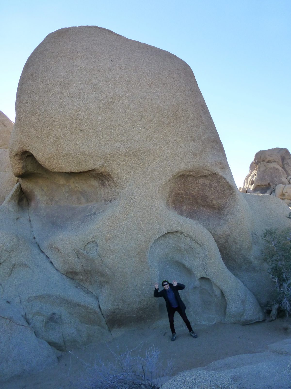
On the way out of Joshua Tree we stopped at Skull Rock. The Skull Rock Trail is a short trail that highlights the non-cactus plants in the desert. Skull Rock really does bear an amazing resemblance to a skull.
Ton mocking skull rock.
We drove from Joshua Tree to Death Valley on a back road that passes thru Mojave National Preserve and Baker California. We were planning to fuel up in Baker as it had the cheapest diesel in the area last trip. Despite fuel prices dropping everywhere else on this trip, the fuel in Baker had actually risen to over $4 per gallon so we passed and drove on towards Death Valley, if we were going to pay an exorbitant amount for fuel we decided we would rather do it in a small desert community, then a large community right on the interstate.
Dantes Peak in Death Valley.
Today we visited Dantes Peak in Death Valley which is an overlook above the main valley. From 5000 feet you are looking the length of Death Valley and can also see for miles back towards Las Vegas. We stayed up for sunset and Ton got some nice shots.
Last night was spent in a great campground in Joshua Tree called Ryan where we were surrounded by granite rocks that make the park famous. We woke up early to the sound of rain and were worried as we had a busy day planned. Luckily the rain quit very quickly and did not amount to much for the day.
Our first stop was to Keys view. On our way up we passed thru a Joshua Tree Forest that Ton really enjoyed. We had been told by the Ranger at Mojave that the Joshua Tree’s here were a different sub-species than the ones at Mojave. Ton says she can see the difference, the trees here are taller and have less branches than the ones in Mojave. When we got to the top we had climbed into the clouds so Keys view was limited to about 50 yards.
Heading down we continued to enjoy the Joshua Trees and the drive. The next stop was the Geology Loop Road which is an 18 mile self guided loop that shows you the different rocks and the San Andreas fault. The park service says it is a difficult 4wd drive road, but in fact it is not bad at all and Scout did not even need to leave 2wd the whole way. We had the entire valley to ourselves for the entire trip which was fun.
Part of Geology Loop Road.
Next stop was the Cholla Cactus garden which Ton loved. The Cholla Cactus is a Colorado Desert plant and the Joshua Trees are Mojave plants to show the impact of the two deserts coming together.
A blooming Cholla Cactus.
The next stop was the Marine Corps Base at Twentynine Palms where we stocked up on food and did some shopping at the store. The last stop was the Indian Cove campground for the night. The campground is also a training base for beginning rock climbers so we got to watch some folks climbing, and even scrambled up a couple of simple rocks ourselves.
Ton commented that the campgrounds at Joshua Tree were among the best we have seen in the park service.
Joshua Tree is a popular destination for rock climbing.
Started heading home as we have a date on Sunday for a Christmas Party and our sons are coming home next week so we have some preparation to do. Had to make an emergency run onto the Marine Base to buy a replacement power cord for Ton’s Mac as hers died the night before.
We basically doubled back the way we came thru Mojave NP and heading north towards Reno, but instead of heading straight to US 95 we decided to run thru Death Valley NP as the main road thru the park parallels US 95.
We made a couple of stops including the lowest point in North America. Near there we ran across a couple of Coyotes who decided to pose for Ton, the first one even responded to her command to heal as she had not finished taking his picture! They both seemed pretty healthy and not at all skittish about people.
This very healthy coyote posed on command for Ton.
We had never seen Scotty’s Castle in the North end of the park so we made that our target for the day. We arrived just a little too late to take the last tour of the day, but got to walk the grounds. The grounds are pretty impressive and the back story is interesting as Scotty was basically a con man who got the money to build the castle by duping people into investing in gold mining operations when there was no gold.
Scotty’s Castle. Crime does pay!
Tonight we spent the night in Mesquite Springs campground which is nice and by a dry creek, that apparently was not dry last week. A flash flood came down the creek and flooded about a quarter of the campground,, but everything seemed back to normal.
Clouds are not a normal part of the sunset here.
Tomorrow will be a long boring driving day heading home.
Ron had always wanted to visit the Racetrack Playa. Ton was a little nervous as the park service puts out very severe warnings about the road and particularly mentions long stretches of sharp rocks. Ron had done some research and several other Tigers had made it out there, though all of the owners had complained about the washboard condition of the road.
We started the day by visiting Ubehebe Crater. The crater is about a half mile across and 700 feet deep and is a result of a recent magma explosion in the park. The crater is quite impressive and a reminder of how suddenly things can change on the planet.
We set out for the playa and Ron thought it could not be much worst than yesterdays drive thru Titus Canyon. In some ways he was right and in some ways he was wrong. The road itself was pretty straight forward with no particular narrow places or washed out sections of road. Looking at it it was a typical gravel road you find in the west. But the washboard was the worst Ron had ever experienced and really beat up the truck and the people inside. We creeped along at 10 miles per hour most of the way and still felt like we were inside a blender.
The valley approaching the race track is really beautiful and you feel like you are really on your own. For the day I think only about 5 vehicles including us went out to the Playa. About 6 miles from the Playa you come to Tea Kettle Junction where there is a tradition of hanging a tea kettle with your name on it. We were not aware of the tradition and did not have a tea kettle to leave.
It is a tradition to leave a tea kettle at the sign, we did not know so we did not contribute to the tradition.
Finally we arrived at the playa. How the rocks moved used to be a mystery, but apparently in November a group from the Scripps Institute were out there and saw the rocks actually moving. To make a short story of a long story it apparently takes a combination of a wet Playa, freezing temperatures that causes ice to build up on the rocks and high winds, and suddenly a 60 pound rock will move on it’s own.
When the conditions are right this rock will move with some help from the wind.
The drive back was no more fun than the drive out there, but we made it back in one piece.
Right as we settled in to go to sleep it started raining. Death Valley only averages two inches of rain per year and we were there for a significant rainstorm.
it was quite warm last night and we enjoyed a good nights sleep without a heater. After we got going we started the day by touring the Golden Canyon. It was a short walk but quite nice. Even at 8:30 it was starting to warm up a bit.
Next we went to the Devils Golf Course. It is on the valley floor and consists of thousands of small humps with salt deposits on the top. It was interesting but a little disappointing for Ron as he was expecting something with more of a golf theme.
Devils Golf Course.
We had visited Artists Point on our first visit about 10 years ago. We had enjoyed the drive so were looking forward to visiting again. This time Ron was a little disappointed with the drive. Ton pointed out that the light was much better in the evening and the last time we had been there in the evening.
The last thing we planned was to take the Titus Canyon road. This is about a 25 mile drive thru the Grapevine Mountains on an unimproved road. The last time we did it in a car so we thought it would be a relatively simple drive. It turned out to be much rougher than it must of been last time, because I do not think we could have gotten a car thru the road as it was today. Still it was great fun and Ton wore out the battery on her camera taking pictures, and Scout handled the road very well.
We are getting used to the drive from Joshua Tree to Death Valley as this is the fourth time we have done it in the last couple of months.
On the way out of Joshua Tree we stopped at Skull Rock. The Skull Rock Trail is a short trail that highlights the non-cactus plants in the desert. Skull Rock really does bear an amazing resemblance to a skull.
Ton enjoying skull rock.
We drove from Joshua Tree to Death Valley on a back road that passes thru Mojave National Preserve and Baker California. We were planning to fuel up in Baker as it had the cheapest diesel in the area last trip. Despite fuel prices dropping everywhere else on this trip, the fuel in Baker had actually risen to over $4 per gallon so we passed and drove on towards Death Valley, if we were going to pay an exorbitant amount for fuel we decided we would rather do it in a small desert community, then a large community right on the interstate.
Sunset on Dantes Peak.
Today we visited Dantes Peak in Death Valley which is an overlook above the main valley. From 5000 feet you are looking the length of Death Valley and can also see for miles back towards Las Vegas. We stayed up for sunset and Ton got some nice shots.
We had planned to head to Zabriske point for sunrise, but everyone overslept. In the end we got there about an 90 minutes after sunrise. Zabriske point was the highlight of our first trip to Death Valley, and Ron in particular has fond memories of the place. We were happy to see that Dang and Noi were more up about Zabriske, so Death Valley had a happy ending.
Zabriski Point.
We had originally intended to target Tehachapee for the day, but when Ton realized we would be there around noon, she extended the drive to Bakersfield. After arriving about 1pm we checked into Orange Grove RV park, which is a great commercial camp ground including you own orange trees in each site. If you are in the area I highly recommend you check it out. As it was still quite early we headed to Costco to fuel up, and see if there were any secret things in Bakersfield that we had not seen in other Costco’s. Yesterday California raised their gas tax by 12 cents per gallon, so even with the Costco discount we had our most expensive gas on the trip at $2.80 per gallon.
We were pleasantly surprised this morning, it turns out we both slept well. We’re not sure if it was because we were really tired, or if the freeway noise acted as a kind of white noise, anyway it was one of the best nights sleep of the trip.
We let the traffic die down for a bit before heading out. It was easy to know when traffic had lightened up as all we had to do was look out the window of Scout to get an up to the minute traffic status.
As we were heading to Death Valley the GPS was routing us thru Pahrump Nevada. Ron finds the name fun to say, and by the time we got there, everyone was coming up with different reasons to include Pahrump in the conversation including at one point a chorus of Little Drummer Boy.
Sunset on the Dunes at Death Valley.
Death Valley is one of Ron and Ton’s favorite parks. It has a stark beauty that really appeals to us, and we were looking forward to introducing Dang and Noi to it. I don’t know if we oversold the park or they hit a wall, but they did not seem as impressed as we hoped. They did enjoy sunset at the dunes, before we headed back to the campground for the night.
We are both still struggling a little bit with our medical issues so it is time to head home so we can see see our proper Doctors. Ron prefers to drive home east of the Sierra Nevada mountains rather than deal with the heart of California so we left San Diego and headed north and east towards one of our favorite National Parks to spend the night.
The drive to Death Valley was pretty uneventful, even the traffic from San Diego to San Bernardino while dense was moving pretty well with no significant slow downs. After you get out of the southern California metropolis, you quickly get into the Mojave and go from bumper to bumper freeway traffic to almost no traffic as you travel thru the desert.
When we arrived at Death Valley we checked in to see what had reopened after the shutdown. It turns out only a couple of the campgrounds have been re-opened so we are in a big gravel lot across from the visitors center with about 100 other RV’s. We took a walk and Ton got some nice sunset pictures, and we had a couple of short conversations with some of out other campers before settling in for the night.
I woke early and prepared Scout for the trip to Las Vegas. As I was leaving the park we drove by Zabriske point and it was sunrise so I pulled in for a quick look at what is my favorite view in the country. While beautiful it was different than yesterday and colder with some wind. I took one picture and then moved on for the day.
Another look at Zabriske point.
With an early start I rolled into Las Vegas about 9:30 am and the check in for the campground was noon so I got directions to a car wash to knock some of the grime off of Scout. I can now touch the side of scout without having to wash my hands. A quick stock up at the grocery, and I headed over and the campground let me check in early.
I met my son Alex for an excellent Mexican meal at a Freida themed restaurant in the arts district. The arts district is an interesting part of Las Vegas. It looks to me like the old downtown before gambling took over the town, and Las Vegas was a rail and cattle stop. After the meal we walked the four or five blocks looking at some funky stores and bars that could fit into Portland, Seattle, or San Francisco. Las Vegas’ little center of hipsterdom.
I woke up early and decided to head over to one of my favorite places. Zabriske point overlooks the gold canyon, and after today I think it is my favorite view in the US. I have been thinking about places that I really enjoy, and Zabriske point at sunrise is hard to beat. My writing style (military log book may be the best description) does not allow me to do justice to the beauty of Zabriske point at sunrise. The way the light cascades over the desert and hits the different colored light is magical to me. I could spend days on end watching sunrises there and never tire of it.
I do not have the photographic skills or equipment to do Zabriske at Sunrise justice.
Now that I was up early I had to decide what to do until my first planned event of the day which was a ranger talk at the old borax production site and mine. I headed over to the visitors center to watch the park movie to get some ideas. The movie was good and I enjoyed it but I did not get any ideas. So I finally just started driving north up the valley to see if anything drew my attention and before I knew it I was near Beatty Nevada which is the closest source of reasonable fuel so I decided to head over there to top off Scout. The fuel at the center of the park is $5.37 a gallon which must be close to the most expensive fuel in the US. There are two gas stations in Beatty one was $3.20 and the other was $3.09 when I tried the $3.09 the pump told me to go see the cashier. The cashier told me that their system was down and they could not do credit transactions, I asked about debit and she told me with a bit of an attitude that it was the same system and today was cash only. I went down the street and paid the higher amount with a credit card.
I ended up being late for the ranger talk due to my running around Beatty. I watched the last few minutes. A lot of the people at the talk were like me attending every talk while they were in the park so I was beginning to recognize faces. One guy told me I had to try the Indian Fried Bread Taco at the Timbisha Shoshone reservation in the park. The Timbisha are the native Americans who lived in this area. I decided to follow the recommendation, though I doubt this is really traditional fare of the tribe as beans, cattle, and corn would not have been native to this area. But as some one in France when I asked if a dance was traditional, he said no, but it could be in a hundred years. So Fried Bread Tacos may be traditional Timbisha food in 100 years. I now have had one, and I can cross it off my list.
One of the original 40 mule team wagons used to haul Borax out of the canyon in the 1880’s, the rear wheels are over six feet tall. The rear wagon is a water tanker as there was only water source on the 10 day trip.
I spent the afternoon hiking Mosaic Canyon a nice flash flood canyon with interesting rock formations. The road to the trail head was a mess and gave Scout a workout, but the first 400 yards of the trail were worth the drive. The ability of water to carve the rocks in the west never ceases to amaze me. The rest of the hike was nice but not super spectacular.
Mosaic Canyon had about 300 yards where water has cut down to the bedrock which is quite pretty.
I ended the day with a nice ranger talk at sunset at Mesquite dunes.
I started the day by heading over to the visitors center to see what ranger talks were available today. I was there as they opened and one of the Rangers was running up the flag for the day. I talked to her on the way back in after the flag was done, she told me there were two talks for the day and she was leading one of them.
So with a little time to kill until the first talk at gold canyon, I decided to do a little exploring. I had noticed a sign for another campground above the one we usually stay in here. The problem with Sunset campground is that there is no electricity so all of the big RV’s run their generators all day to power all of the stuff in them. They require generators to be shut down from 7pm to 8am, but nothing ruins sitting outside to enjoy the sunset than the buzz of three or four generators running around you. The Texas Spring campground costs $1 more than Sunset but is generator free and prettier so I moved up here and bought two nights.
Part of Artists Pallette Drive. A really nice one way drive in the park on the way to Badwater.
The first talk of the day was in gold canyon which is one of Ton and my favorite hikes in Death Valley. The person leading it was not a ranger but a young man on an internship at the park. He took the duty very seriously and one thing I learned is that some of Star Wars 1 The Return of the Jedi was filmed in the canyon. Besides that I learned a great deal about fan canyons which Death Valley is famous for.
Gold Canyon.
The second talk was at Badwater Basin which is the lowest point in the Western Hemisphere at 280 feet below sea level. It is one of the must stop photo stops in the park. Besides being the lowest spot in the West it is also an interesting salt flat, and does have a spring which is 4 times saltier than sea water.
Badwater Basin, the lowest spot in the Western Hemisphere.
I returned to Texas Springs for sunset and climbed a hill above the campground to watch the sunset. Since the mountains on the west side of the valley are about 5000 feet higher than the valley but quite close, sunset happens about an hour and a half before the light fades which is kind of weird.
The day began with indecision. Thomas’ offer to attend his brewery event on Saturday was very tempting, so we began the day by looking at options to do around Reichnau until Saturday. The other issue is the weather. Today and tomorrow are the only two good days forecast in the next 12 days. After today and tomorrow the Weather Channel App shows 10 consecutive days of miserable weather for Southern Germany, actually for most of Germany. Ton even researched weather in other parts of Europe to escape the cold and rain. Right now Oslo has the best weather, but it is a bit far away. The interesting thing is that the temperatures are going to be warmer in the North of Germany than in the South, also the forecast showed slightly less rain in the North.
St. George Church, our last stop on Reichenau Island.
We still really wanted to take Thomas up on his offer so we talked about options including Switzerland (really expensive), just settling in Reichenau but we needed supplies mostly LP gas. With the cold weather every night we are using a tank of LP every 4 or 5 days ( for comparison we used two tanks in 6 weeks on our trip to Spain). After looking at options around the region we finally decided we needed to get going North towards the less lousy weather, so today we are in the Alps near the Austrian border.
Mountain valleys with many small farms, and villages. The population is much denser in Germany than in Spain or France.
When we punched Garmisch into Greta Garmin she told us it was about 3 hours to drive the 250km’s, we add 30 minutes to all of her estimates as we are usually under the speed limit. It still sounded like a pretty reasonable day. The first problem is around Freidrichshaven we ran into really heavy traffic, so the first 100 kilometers of the trip took 2 hours, after we broke out of Freidrichshaven traffic thinned out, and then we found ourselves on the autobahn so all looked good. With about 80km’s to go I noticed a sign that said we had just entered Austria, did not know that was going to happen, after a few minutes I remembered that Austria requires a vignette to drive on their roads. A vignette is a sticker you buy in place of paying tolls, many countries require these ( one of the reasons we did not go to Switzerland is that they require an annual one that costs 40 Swiss francs). So now we were outlaws as not expecting to enter Austria I did not research how to get a vignette or how much it would cost. I decided to press on as our final destination is in Germany so I figured we must just be cutting thru a corner of Austria.
The dandelions were out in force as we drove thru Austria.
All was looking good as we had spent the last hour in Austria driving thru magnificent mountains and gorgeous valleys carpeted with flowers. We passed back into Germany without getting fined, when we were 8km’s from the campsite for the night we came to a barrier across the road. This was in a narrow mountain pass, so there was no local by pass. Much cursing because when we turned down this road about 30 minutes earlier there was no indication that it was closed.
Typical of the roads in Austria, the mountains were spectacular.
So I told Greta to find us another route to Garmisch, her alternative was 80 km’s! Lots of cursing now, as we are literally 10 minutes from our destination, and the detour is going to take nearly 2 hours. So back up the road illegally into Austria again. The next detour routed us thru a national park with narrow steep roads with views of glaciers and glacier fed lakes, not a fast route but really gorgeous and nearly worth the trouble.
The large glacier fed lake in Brentanwag National Park on the road we took on our detour caused by construction.Another view from our unexpected detour.
After 6 hours of hard mountain driving we arrived in Garmisch, and just before the turn into our campground we saw signs for a US Military compound. After settling in we took a walk down there to see what they had. It turns out it is a recreation center complete with hotel, 3 restaurants, and big American washing machines. We had a beer and nachos while watching American sports. We are planning to return tomorrow with a load of washing. A nice end to a hectic day.
Woke to blue skies, so morale is up for the day. We decided to spend another day here to further explore the area. As we walked into town we decided to head over to Mainau Island to explore what is called the Flower Island.
We had not done any research, but knew we had to take a ferry there. The ferry was a little expensive, but the shock was the lady who sold us the tickets said there was a €20 charge to get onto the island once we landed that we should buy on the boat ride over. At this point we were committed so on the ride we were feeling a little guilty about the cost, questioning our decision, and vowing to do more research next time.
Meersburg from the ferry as we were leaving. The castle is in the upper left.
When we began the walk it became clear that the decision was a good one. The island which is 110 acres is a giant botanical garden that is really well done. The island is owned by a Duke and Duchess and was originally a Grand Dukes residence. There is a strong Swedish royal connection, and the Swedish flag flies conspicuously on the residence.
A really cute topiary that greets you when you enter the island celebrating the flower island theme.
During different times of the year they feature different flowers and for April and early May it was Tulips. The flower gardens featured over a thousand varieties of Tulips interspersed with other flowers.
Some of the tulips on display with other flowers mixed in, really well done.Another beautiful flower patch with the Swedish tower in the background.
In addition they had a petting zoo full of cute animals, and a butterfly building with thousands of butterflies flying around that we got to walk thru.
A Shetland Pony pony that Ton thought was really cute.Ton’s favorite butterfly amongst the thousands in the butterfly building.This lady was kind enough to pose for a couple of minutes while Ton and several other people took pictures of the butterfly in her hair.
Their Arboretum was full of very interesting trees most of which we could not identify, but interestingly they had about 15 or 20 Sequoias from California. Beside the tulips there were other flower gardens including poppies, and rhododendrons.
A giant sequoia that had been moved from California at some point.Ton loves poppies.
While we may not have known what we were getting into when we got on the ferry there was no doubt that it was a great decision. Mainau is by far the best botanical garden we have visited in the world. What we thought would be a quick couple of hour visit turned into a whole day on the island.
The Alps towering over Lake Constance.
We ended the day by visiting the most famous winery in Meersburg Staatsweingut. We tried a couple of their whites, a red and a rose that was labeled Spätburgunder we liked the rose and asked what grape it was made from. After some asking around amongst the staff it turns out that Spätburgunder is German for Pinot Noir.
Heart shaped vines outside the tasting room at Staatsweingut.
Today was about Flamingos. After some muddling about in the morning and doing some laundry we were off to the Camargue which is a large delta where the Rhone River empties into the Mediterranean. It is a famous bird sanctuary.
There is an ornithological park as you drive into the delta, and we decided to stop and take a look not knowing what to expect. It turned out to be a great walk where we were surrounded by many different kinds of birds but the star attraction for the average Joe (or Pierre) were the flamingo’s. There were hundreds of them on display. Ton wore her battery out shooting pictures of them.
The bodies are slightly pink, but the wings are quite striking as this bird is showing. These are Rose Flamingo’s native to Africa, and Europe
It was a really nice walk and in addition to the flamingos there were a lot of Heron’s. In fact the serious photographers with the long lenses were ignoring the flamingos and shooting the Herons. There must of been something significant over there, but we did not figure it out.
All of the serious photographers were concentrated around this area, we are not sure what the attraction was.
After a couple of hours of exploring and pictures we headed down the road to the sea to visit the town of Saintes Maries de la Mer. Driving in it did not make much of an impression on us. But when we pulled into the aire we figured there must be something to the town as there were easily 70 or 80 RV’s in the aire. We took a walk and it was a seaside resort, not a particularly fancy one, but pleasant. We decided that we would have dinner tonight to compare French seafood with Spanish. Spanish won.
The Mediterranean is apparently warm even in April, as the water was full of kids playing.