We slept in today. Between the long drive and the wind yesterday we were pretty worn out. As we were working on breakfast I realized that today was the end of the Premier League season, so a quick search of the TV and we found the Liverpool game. Our morning was set, we sat back enjoyed our coffees and watched the game.
The Sawmill Market was a restored historic building with a bunch of cool restaurants.
After the game was over we decided to head into the old town in Albuquerque. When we parked Scout on a side street we saw an interesting place up the street called the Sawmill Market. We decided to check it out and it is a historic building that has been converted into a bunch of restaurants and small food shops. It really reminded Ton of similar places we have seen in Europe, particularly one in Lyon, and another in Turin. We were tempted to try a couple of the restaurants but were holding out for a special dinner we had planned later.
Ton loved this combination of the adobe building, roses and the window with bars in the old town of Albuquerque.
The town was founded by the Spanish in 1706. The old town is built around a typical Spanish colonial square with small roads branching off of it. The old town is full of artist galleries, tourist stores, and restaurants. It is a nice walk and the old adobe buildings are interesting to look at.
This church dates from the late 1700’s and is made of adobe. It replaced the original church which was built in 1706.
We popped into the Catholic Church which was built in the 1790’s. It is a Spanish Mission style church made of adobe. The walls of the church are over 5 feet thick to help keep it cool during the hot summer. While it is small compared to the giant cathedrals we have been seeing in Europe, we were quite taken with it.
Ton loves cactus and this flowering one was lovely. She also liked the mariachi’s on the roof of the restaurant.
One of our friends in Oregon takes care of our mail when we travel. She lived in Albuquerque about 25 years ago, and when we told her that we were visiting Albuquerque she told us her favorite Chinese Restaurant in the US is here. As she is from Taiwan we took that as a good recommendation. We had planned to go there for a late lunch but they did not open until 3 pm, so it turned into an early dinner. When we arrived a little before 3 we were the only customers, but the waitress was very friendly and handed us a large book like menu. After we told her our friend had recommended the place she grabbed the book, took one laminated page out of it and said this is the menu for Chinese people. After consulting with her we picked duck and a seafood hot pot. Ton pronounced it the best duck she has had in the US, and the seafood hot pot was excellent. Thank you Miriam for a great recommendation you were right it is one of the best Chinese restaurants we have been to. If you are ever in Albuquerque check out East Ocean Restaurant
Today is going to be a short one as the day was mostly spent driving about 350 miles in a constant 35 mile cross wind. The day started with a surprise when I realized the water hose had frozen over night. I knew it had gotten cold and turned the heater on in Scout about midnight. In the morning I joined 3 other RV owners who were planning to leave in hauling our hoses into the sun to melt the 25 ft ice cube inside.
I spent most of the day wrestling Scout down I-40 along with a surprising amount of traffic. The trip took about an hour longer than planned due to the traffic and the need to slow down due to the wind. On top of that I forgot that we changed time zones crossing from Arizona to New Mexico. So instead of arriving about 3 pm it was nearly 5pm when we parked for the night.
Another Eagles fan standing on a corner in Winslow Arizona.
Our one stop for the day was in Winslow Arizona. The other day one of our long drive conversations was about which 5 albums we would take to a desert island. The only one that was on both of our lists was The Eagles Greatest Hits. So when we set off Ton said we had to swing thru Winslow to visit the corner. If you are an Eagles fan you will know immediately what I am talking about. If you are not than I will quote you a famous line from their first hit “Take it Easy”, the line is “Standin on a corner in Winslow Arizona.”
The corner in Winslow Arizona. Bonus points if you know the significance of the red truck on the right side of the picture.
Recognizing a good source of revenue the town of Winslow has dedicated a corner to the Eagles and it draws quite a few people into town. In addition to the park, there are two stores dedicated to The Eagles and Route 66 memorabilia. After doing our part to contribute to the economy of Winslow we were back on our way.
This shack is billed as the “Worlds Smallest Church”.
We are settled in for the night, but it feels like we have swapped our RV for a boat, as the constant buffeting of the winds has us rocking around like we are at sea. The wind is supposed to continue all night so hopefully we won’t get seasick.
In the middle of the night we were surprised to hear rain on the roof of Scout. The weather man on the radio yesterday was adamant that while the winds were going to be steady at 35mph with gusts to 50mph there was going to be no rain. He was right about the wind, which for the last 24 hours has been extremely strong, but he was very wrong about the rain. It turns out the rain was a good thing as it prevented today from turning into a sand storm because of the steady high winds.
Today we picked as our destination two National Monuments that share a common road, one is a natural feature, and the other is a historic site. Our first stop on the tour was Sunset Canyon National Monument which is a volcanic cinder cone and lava lake. We swung thru the visitors center which is still closed due to Covid restrictions, but the bookstore was open so we got some information about the two monuments to plan our day.
The Lava Lake at Sunset Crater National Monument. The Sunset Crater Volcano is the cinder cone in the background.
Our first stop was the lava lake which was very similar to formations we have in Oregon. The cone was formed about 1000 years ago during a series of volcanic eruptions in the area and is about 1000 feet tall. The lake was formed at the same time when lava surged to the surface thru a fault and settled into low ground. While the surface of the cone is volcanic, it is quite different than the lava in the lake due to how it emerged. We enjoyed a short hike thru the lava, and stopped at a very windy overlook to take in the Cinder Cone.
The Sunset Crater Volcano.
Wupatki National Monument is a series of Native American dwellings that were inhabited from about 1100 to 1250 AD. At it’s peak about 2000 people lived in the area practicing low water farming and acting as a trading hub for surrounding Native American people. After 1250 the dwellings were abandoned and most of the people left the area as the conditions were too harsh even for low water farming.
Wukoki Pueblo. The interior of the building on the left is very well preserved.
The environment in the area and the lack of people due to the harshness of the surroundings caused the dwellings to be well preserved and unmolested when they were placed under the care of the park service in the 1930’s. Our first stop was the Wukoki Pueblo which was the home for about 3 families. It is located on top of rocks and was built to 3 stories. Of all of the pueblos it is the most accessible to the public. You can actually go into some of the interior rooms which was fun.
Wupatki Pueblo. The circular feature on the right is believed to have been for religious functions.
The highlight of the monument is Wupatki Pueblo which was the religious and central trading area for the region. It has over 300 rooms and a ball court and religious meeting area. It is fascinating to walk the exterior to see all of the various rooms, and to try to guess the purpose of each room. I found it interesting that sports were important enough to these ancient people that a dedicated structure was built to host the games.
A close up of the Wupatki Pueblo showing the size and intricacy of the masonry.
We stopped at one more pueblo where the wind was blowing so strong that I had to hold on to Ton so that she could steady herself against the wind to take pictures. I have never experienced such strong winds over an entire day anywhere in the world. It was really relentless. We were each knocked off balance several times during the day by gusts around 50 mph. The only other times I have seen winds like these were during hurricanes or severe storms. Today we had the winds of a storm on a bright and clear day.
Yesterday we decided to head east a couple of hundred miles to Flagstaff AZ. Our base for the next couple of days will be Camp Navajo which is operated by the Arizona National Guard. When we arrived I missed the turn into the campground and ended up down a pretty rough road before I conceded that I must have missed the turn. Eventually we found the camp and got the next to last spot available.
Mather Point near the visitors center at Grand Canyon NP
After lunch we decided that a quick trip out to the Grand Canyon would be a nice way to spend the afternoon. We are lucky to have the flexibility to just drop into the Grand Canyon on a whim. On the way there we were trying to remember how many times we have visited the Grand Canyon and we believe that today was the fifth trip to the south rim, and we visited the north rim once.
Enjoying the view.
They are starting to open up more of the facilities but the visitors center is still closed, and a lot of the restaurants are operating as take out only. The only Park Service people we saw were a maintenance crew working on one of the bathrooms. The signs said masks were required but only a small percentage of the visitors were wearing masks.
The other big difference was the lack of foreign tourists. Usually as you walk along you hear a lot of different languages as the Grand Canyon is one of the highlights of a visit to the US for overseas tourists. Today it was overwhelmingly American English being spoken. Covid has caused Americans to rediscover the national parks. Hopefully we will be able to share the Grand Canyon again soon with visitors from overseas.
The canyon itself was magnificent as usual. It is really an awe inspiring place and I could be happy visiting it daily.
Two observations about traveling. The first night of the trip the sunset was at 8:38 we looked it up, tonight driving back from the canyon at about 7:00 I told Ton it looked like the sun was getting ready to set, I was right. We have traveled far enough south that the days are two hours shorter than in Oregon. The sun set at 7:32 today. Yesterday we were at sea level where the temperature was 101f, tonight we are at 7000 feet and the high temperature is 72f. What a difference in conditions a 200 mile drive in the same state can bring.
We had a debate about whether to stay another day. We booked two nights at the State Park, but we had no idea that the temperatures would be over 100 degrees. I called the reservation for the Arizona State Park system and they told us no same day cancellations so our debate ended.
The main attraction in Laughlin
So we decided to get the London Bridge out of the way before it got too hot. We headed down there about 1030 am and it was already 93F. Our initial reaction on arriving at the Bridge was is that it? They had some shops around one end of the bridge with a British theme. There were a lot of vendors renting boats, jet skis, and selling river cruises. The one that got our attention was a floating bar that went out on a two hour cruise. This one tempted us as we have never seen a floating bar before.
The floating bar we were tempted to sign up for.
When we got to the end of the waterfront we saw a sign for a water taxi to the Indian Casino on the California side of the river, and the cost was only $2 per person roundtrip. This is our kind of river cruise so after a quick lunch we were on our way to California.
The view of the harbor at Lake Havasu from the water taxi.
The ride over was nice and the combination of being on the water and the breeze from the boat cooled things down nicely. The casino was very small but it was the first non-smoking casino we have ever been to so it was the cleanest we have ever seen. After sipping on a beer we headed back to Lake Havasu.
Maybe the weirdest tourist attraction in the US.
We ended the day at a local brewery at the airport called Hangar 24. The beer was good and we soaked up their air conditioning for a couple of hours while sipping on a single beer. As we were thinking about leaving a country music duet started up. They had just moved here from Oregon and were just as shocked with the heat as we were. We enjoyed a set of their music before we had to head back and set Scout up for the evening.
Today is going to be a short one as we spent most of the day driving and when we arrived at our destination it was too hot to do much more than sit in the shade and sip cool drinks.
Our destination for the day was Lake Havasu City in Arizona. It is a relatively new vacation/snow bird destination founded in 1964 on a wide spot on the Colorado River. It is known for extreme temperatures and the London Bridge. When the founder of the town was struggling to get the towns name on the map he decided to buy the London Bridge which was in the process of being replaced by a more modern bridge in London. As the bridge was removed each piece was marked and staged to be shipped across to Arizona to be reassembled on the Colorado River. It is rumored that the founder originally thought he was buying the Tower Bridge which is the famous landmark bridge everyone knows from London and not the relatively non-descript London Bridge. As goofy as the plan sounds it worked, the London Bridge is the second most visited tourist spot in Arizona after the Grand Canyon, and it got Lake Havasu on the map.
We knew that we risked it being a little hot as temperatures in the summer can reach 115 Fahrenheit (46 Celsius). We thought it is only May so worst case would be something in the low 90’s. When we arrived it was 103F (39.4C), which even intrepid travelers like us find a bit much. So after we hooked up we hunkered down in the shade and hoped for a breeze which never came.
The shore at the beach we are staying at. The entrance to the boat ramp is at the light house in the upper left corner of the picture. While the town is called Lake Havasu it is really a wide spot in the Colorado River caused by a dam up river.
We decided to brave the heat to walk down to the river at sunset. It was a beautiful sunset over the river. This is also a big water sport playground so we watched some of the boats come in to be hauled out of the water for the day, this is always entertaining as some of the drivers technique for backing the car and trailer into the water is not so good and can result in some hilarious interaction between the driver of the boat and the driver of the trailer.
Now we are settled in and since we have access to electricity we are wimping out by running our AC to cool down Scout before bedtime. The plan is to head over to the bridge tomorrow morning before the heat gets too bad.
We were up bright and early at 5:20 am to catch the sunrise on the Alvord Desert. It lived up to its billing and was worth the early wakeup call. I also got up at about 2:30 to use the facilities and on a whim stuck my head out to look at the sky. It was absolutely fabulous. The Alvord is located over 150 miles from the nearest city, and the nearest town is over 100 miles away so the night sky is truly dark. There were thousands of stars out and the milky way was clearly visible it was spectacular, in fact it was so good that Ton did not complain when I woke her and dragged her out of bed to look at it. Unfortunately we did not bring a camera so you will have to take our word for how beautiful it was.
Sunrise on the Alvord Desert.
Since we were up, we decided to get an early start on a long days driving. Today we drove about 400 miles thru the Great Basin of Nevada. The desert here is huge and while the topography is very similar for the whole drive, large valleys at about 4000 feet elevation ranging from 15 to 20 miles across with mountains on either side of the valley around 6000 feet. It is extremely dry and the plant life is similar the whole way. Some people find it quite tedious, but Ton and I really enjoy it. There are no oh wow beautiful sites, but the shear size and distance to us is awe inspiring.
It is an extremely inhospitable place with little water and extreme temperatures so towns are very few and far between, typically around 100 miles between towns with any service such as fuel or food. All you see of people are ranches every few miles and an occasional mine. Due to the lack of population the armed forces use the area for low altitude flight training. Today we were buzzed twice by a F-35 fighter flying at 200 feet. Both time we did not see the plane until it flew straight over us. It is quite startling to be cruising along without a car in site only to have a fighter jet go straight over head at high speed. The pilot was nice enough to give us a little waggle of their wings to acknowledge scaring the heck out of us before disappearing out of site. Again no pictures as it is hard to get a shot of a jet pulling away from you at 450 knots or so.
Nice Ferrari. The person in front of me in line won the free room by rolling a three of a kind on the dice.
Tonight we have moved to the much less exotic RV park behind the casino in Tonopah Nevada which is one of the mining towns I talked about above. It seems to be having some kind of a boom as there were a lot of workers staying in town with their pick up and work trucks, a couple of the hotels that have been abandoned for years have been remodeled and reopened, the RV park behind the hotel is completely full tonight as people are starting to feel more comfortable venturing out on vacations. It does look like things are starting to move towards normal, though no one seems certain where or when they are supposed to be wearing masks.
As we were driving thru town we saw the sign for the Tonopah Brewery so our evening was planned! The Kolsch beer was really good, and the barbecue was also excellent. If you are ever in town I highly recommend them.
Bobs Big Boy is a California Icon and has featured a couple of movies. I have the stout figure but unfortunately not the hair.
Finally after 15 months stuck at home due to Covid we are back on the road again. Now that we are cleared to go mask less outside we decided it was time to get out again.
We had originally planned to leave a couple of days ago, but I have been waiting for my new drivers license to come in the mail. My license expired during the pandemic, and the DMV (Department of Motor Vehicles for our non-American friends) was by appointment only due to COVID restrictions. Despite going on line daily I was unable to get an appointment to renew my license. I did get a letter in the mail saying that the police departments in Oregon would be lenient on expired licenses due to the pandemic, so I was not too worried in Oregon. The DMV then announced that you could renew your license on line starting on May 5th. I renewed promptly on May 5th and printed out my receipt which covered me for 30 days. After waiting 10 days for the actual license to arrive in the mail, we decided we could not wait any longer and asked our neighbor to monitor our mail. When it arrives we will arrange to have it mailed to us on the trip.
Having taken care of all of the administrative and logistics we were ready to take off this morning. We picked the Alvord Desert as our first nights destination. Spending the night parked on the floor of the dry lake bed has been on my bucket list for a while and it is more or less in the right direction.
Some of the fire damage along the Santiam River. It is by far the biggest and most intense forest fire we have ever seen.
We took a route along the Santiam river that took us thru a major forest fire from last year. We have driven thru forest fires and the aftermath of fires many times. Oregon had a particularly bad fire season and the Santiam Fire was reportedly one of the most severe ever in Oregon. Despite knowing that we were both shocked at the extent and severity of the fire damage. For over 30 miles we drove thru incredible scenes of devastation. The road has a reduced speed limit due to the thousands of fire damaged trees adjacent to the road that need to be removed. The town of Detroit that our son Dylan spent one summer as an intern with the Oregon State Parks was completely burned out. Unfortunately this may be our future, as April and May so far have been very dry and warm this year which may result in another bad fire year.
After a longer drive than I planned we arrived at the Alvord Desert about 5 pm. The Alvord Desert is not a desert (though it is located in a desert that only gets 8 inches of rain per year), but a dried lake bed that is 12 by 7 miles. It is similar to the more famous Bonneville Salt Flats in Utah. The woman’s land speed record of over 520 mph was set on the Alvord in 2019.
Scout trying to break the land speed record for RV’s. We just missed!
The Alvord is public land and when it is not being used to set world records it is open for camping, driving, landing aircraft and other activities. I have always wanted to try it out. It is in a very remote part of the state at the base of the Steens Mountains. It is about 100 miles to the nearest major town, and the last ten miles to the Lake are on gravel roads, so while the usage is unregulated, there are not a lot of people using it so common sense mostly prevails and people stay out of each others way.
Toasting our unique campsite on the Alvord Desert.
We were pretty tentative when we first arrived and only drove Scout out a short way before stopping and walking around a bit. After we were convinced that Scout would not break thru and become mired in mud, we took her on a drive across the lake bed which was pretty fun. It is amazingly flat and mostly very smooth. There were a few other people playing and we did see one small airplane doing a touch and go so it is true about the airplanes. We were having so much fun goofing around that we forgot to photograph sunset, but we are aiming for sunrise tomorrow.
Ton and I recently completed a couple of short trips in the Pacific Northwest and as we were driving we found ourselves comparing the experience between camping in the US and in Europe. We also spent some of that time discussing our impressions of costs. So when we returned from our last trip I decided to take a look at the spreadsheets we keep when we travel to see the differences.
While we travel we keep an excel spreadsheet where we record all of our daily costs by category. We have been doing that since 2016 so it includes all of our trips to Europe, our Alaska trip, and our trips in the US. For this post I am comparing our two 2019 European trips, with two shorter trips we took this year in the US. The costs for Europe are averaged out over 110 days, while the costs for the US only include 24 days.
For this post I am only including the costs actually involved in traveling from the time we leave our home in Oregon until we return. The year we traveled to Europe we used airline miles for both sets of flights, so the airline costs are minimal. I am not going to include cost of ownership items such as maintenance, storage, insurance, and depreciation because I have not been very good about recording the costs associated with Scout our US RV.
In our spreadsheet we track the following costs associated with daily RV life:
Fuel
Eating Out
Camping
Entrance Fees (Parks, Museums)
Internet Access
Tolls (Includes costs of ferries)
Laundry
Public Transit
Groceries
Lodging
We are type A travelers so we move very frequently. An average week for us has about 4 different locations where we spend the night. Also, one of our favorite reasons to travel is to sample local foods, beers, and wines, so we eat out fairly frequently. Because of this our average daily costs may be a bit higher than many people. Also, the costs are expressed in US dollars, we keep our spreadsheet while we are in Europe in both dollars and Euros and update the exchange rate daily. It is not perfect but I think close enough.
Crossing from France into Spain.
Overall
The average daily cost for Europe was lower than the US. This surprised me a little as we have daily costs in Europe that we do not incur in the US. It was not a total shock because both Ton and I thought that overall it would be close, we just thought it would slightly favor the US.
Update 2022: Without going into details our costs for our travel in 2022 in Europe did not change significantly from what we are reporting below. The higher cost of fuel caused by inflation and the Russian war on Ukraine were for this trip offset by a significant strengthening of the dollar compared to the Euro. Food costs like in the US have gone up both in grocery stores and at restaurants but at roughly the same rate as inflation in the US so again a wash.
Lower cost Europe by $7 per day.
Driving down a long lonely road in Eastern Oregon.
Fuel
The biggest difference between the US and Europe is not surprisingly fuel, but it does not favor the side you would think. Everyone knows fuel is much more expensive in Europe than the US. Last year while we were traveling fuel costs in Europe were approximately $6 per gallon. During our travels in the US this year fuel was around $2.50 per gallon. Scout’s 6.8l diesel with automatic transmission burns fuel at about 13.5 miles per gallon. François’ 2.2l with manual transmission gets much better mileage at about 20 miles per gallon. The biggest cause for the difference is we travel much farther per day in Scout than in François. Looking at our expense log due to the difference in miles driven we fuel Scout almost every day. In contrast because things are much closer together in Europe we end up fueling François only every 5 to 6 days. I thought maybe this was an anomaly caused by the trips we took in Scout this year, so I went back and looked at the expenses for 2016 and 2017 and they were very similar for fuel to what we see in 2020. So it is more about miles driven per day in the US. So even though fuel is much cheaper in the US we end up spending substantially more per day on it in the US.
Lower cost Europe by $33 per day.
Small neighborhood market in Sicily.
Groceries
Our impression was that groceries were slightly more expensive in Europe than in the US, and that is how it turned out. The difference this year was more substantial than in past years. I attribute that to the fact that this year we only had one long trip that we had to purchase groceries. The other two trips were only a week and we did not purchase food on those two trips but stocked the fridge from home. We did not have any costs on those two trips. When I looked back at our longer trips from 2016 and 2017 the average cost was lower than Europe but only by about $2 per day.
Lower cost US by $6 per day.
One of our favorite things to do while we are traveling.
Eating Out
Experiencing the local food is a big part of why we travel so we budget for eating out a few times per week. We were pleasantly surprised by eating out in Europe. The fixed price lunch is one of our favorite things there. We thought that eating out would be more expensive than at home but it has not turned out that way. The menu prices are higher than in the US, but they almost always include the service charge. When you factor in a typical tip of 18 to 20% the lower menu costs in the US evaporate. What we found is that our costs were very similar in both places and for the time we are looking at they were slightly lower in Europe.
Lower cost Europe by $2 per day.
Lodging
We budget one day a month for hotels this allows us a little break from François and some cities are easier to see from a hotel. Also, we stay in a hotel the day we arrive in Europe and the day before we depart. Currently because of my pre-retirement life as a consultant we have a ton of hotel points available to cover these nights so the cost is pretty minimal. In Europe we will sometime stay at US military short term quarters as it gives us access to the American washers and dryers there.
Lower cost US by $2 per day.
An “Aire de camping” in France, basic and cheap.
Camping
Before we left the first time for Europe I would have guessed that our camping costs would have been higher there than here. But as we traveled the first time, the well developed RV infrastructure and the variety of options to park were striking in Europe. This was the biggest surprise for me.
The opportunities to free camp there are many and we met a lot of people who took great pride in almost never paying to park. We tend to avoid urban free camping as we are just not that comfortable with it. The opportunities in Europe are probably greater than in the US, but like here because of abuses by a small number of people, becoming more difficult. We probably free camp (usually in a parking lot ala Walmart parking) about 10% of our nights.
Europe has something that I have not seen in the US and it really helps with camping costs. Each country calls it something different, but it is a parking area usually sponsored by the town or city that is designated for short term stays by RV’s. The services offered vary from a designated corner of the municipal parking lot with no amenities, to very nice facilities with water, dump stations, and even toilets. These are not posh facilities, usually just asphalt with no expectation to enjoy the outdoors. The great thing is the cost. They range from free to $10, with the norm being around $5. We probably spent around 50% of our nights in these facilities while traveling in France and Germany.
We also find that our Campground costs are lower than in the US. These are the equivalent of RV parks here. We are traveling in the shoulder season there and in Europe there is a camping organization called ACSI that is something like Passport America. The ACSI campgrounds generally go for $15 to $20 per night for a full service (electric, water, shower block) campground during shoulder season. As RV sales have taken off and demand has increased we are finding that RV parks even in the shoulder season are running $25 to $45 per night in the US.
So even though we most often camp in National Parks and other US government campsites and get our senior discount, the additional cost of US RV parks pushed the average daily cost in favor of Europe
Lower cost Europe by $8 per day.
Sometimes we just join with all of the other tourists!
Entrance Fees
We are very much in tourist mode while visiting Europe so our costs for sights is more. In the very popular sites in Europe we often find ourselves paying for guided tours which even raises the costs more. In the US we are now eligible for the lifetime senior discount card. This gives us free entrance to National Parks, and other US facilities. This has taken away our biggest entrance cost while touring in the US.
Lower cost US by $5 per day.
Internet Access
In a previous post I talked about our way of maintaining internet access. In the US we do not need this as our cell phone service provides it. Our cost for internet access in Europe gives us about 100 gb of data per month, and represents a discount for long term usage and taking advantage of periodic discount offerings from the provider we use.
Lower cost US by $5 per day.
Tolls
In the western US toll roads are pretty much limited to the Los Angeles and San Francisco areas and a few stray bridges. In Europe outside of Germany and Belgium most freeways are tolled. We try to avoid them, but there are times when they are unavoidable. Also, during 2020 we traveled in Italy and made the decision to use the freeways whenever possible and pay the tolls due to the quality of the secondary roads.
Lower cost US by $7 per day.
Laundry
One of the biggest chores for us is finding good places to do laundry. Laundry is more expensive in Europe. It typically costs $6 to $8 to wash and dry a load.
Lower cost US by $2 per day.
We have come to depend on the excellent public transit in Europe.
Public Transit
We almost never use public transit in the US. In Europe we frequently use it to get from the campsite to downtown, particularly in mid sized and large cities. In 2020 we also used a ferry to get from southern France to Sicily which was a bargain though it drove our cost per day up.
Lower Cost US by $10 per day
For us now that we have invested in a RV in Europe there is no significant difference between traveling in the US and in Europe on a daily basis. If you enjoy RV’ing in the US you will enjoy it in Europe, it is affordable, fun, and gives you another view of living on the road.
You can see our thoughts on shipping your American RV to Europe vs purchasing one there in this post Purchasing our RV in France.
The weather is deteriorating and there is a chance of snow overnight. We had planned to go home tonight or tomorrow, so the weather made the choice an easy one for us.
When we set out we thought we would only spend a couple of nights in the Yakima Valley, but we ended up staying 4 nights. Our planning was a little off this trip as we ended up winging our days, and probably drove a couple of hundred random miles because of our poor planning. But we do enjoy seeing things in the back country so except for the extra cost of gas it did not particularly bother us.
One of our unplanned highlights of the trip, Bombing Range Brewing in Richland. Ton loved the hazy IPA so much see bought a crowler to go.
The nice part about the trip is each day we ended up finding a place that we really enjoyed and was memorable for good food, drink, and fun people. None of these places were on the agenda at the beginning of the day when we set out. So while it may not have been an efficient week, spontaneity led to positive experiences. This seems to happen to us very often and rarely do we have the opposite experience where things go badly. I think these kind of finds are what we enjoy about traveling.
The vines were just beginning to change colors at Idiots Grace Winery.
Driving down the Columbia River Gorge Ton proposed we make one more stop before home so we pulled into one of our favorite Gorge Wineries, Idiots Grace. They had just reopened with a tented and heated tasting area. We had a quick lunch from Scout pared with a tasting of wine. The weather was crisp at about 50 degrees but it was a good end to a very nice trip.
We decided to extend our stay in our current campground, so we took a little extra time this morning. After looking around for options to do today we decided to head over to Saddle Mountain Wildlife Refuge to start the day and once we were done there decide what was next. We know that this is a very vague plan. The other decision for the day was whether this was going to be a wine tasting day or a beer tasting day. The final decision was for beer, so now that we had an agenda for the day.
The Columbia River passing thru the desert. The source of water for the crops in the region.
We set Greta to no freeways as we wanted to get where we were going by driving thru the verdant farm country in the Yakima and Columbia Valleys. We both really enjoy driving down country roads trying to identify crops, and looking at the different ways farmers manage crops. This area is known for three major crops now. Apples have been the major crop for generations, but about 40 years ago they began planting warm weather varietals of wine grapes and it now a major wine region. The third major crop now is Hops. Hops have been grown here for decades, but since we last visited about 10 years ago hop production has exploded in the area, and today we drove thru thousands of acres of hop farms.
These apples were being harvested as we drove by.
We were enjoying our drive and looking forward to the Wildlife Refuge. As we left the Yakima River Valley we entered the high desert grassland this area is naturally without irrigation. For about 20 miles we were skirting the edge of the Hanford Nuclear Site. During WWII this area was very remote and sparsely populated, so a top secret facility was built out here with some of the earliest nuclear reactors. At the peak the Hanford Nuclear site had 9 reactors to produce plutonium for nuclear weapons. The nuclear matter for the Manhattan Project was produced here. The production sites are now deactivated though it is one of the largest storage areas for used nuclear material in the US. At one point we came to one of the guarded entrances to the site. It did not seem like a good idea to stop and take pictures so we have nothing to show.
After leaving Hanford we had crossed over into the Columbia River Valley and the apples, and grapes reappeared, but more corn than hops. We were following Greta Garmins directions as we drove along and she finally had us turn down a gravel road into a large apple orchard, Greta finally announced we had arrived at the wildlife refuge when we were surrounded by apples with a large expanse of desert in front of us. The desert was probably part of the wildlife refuge but it did not appeal to us, so we turned around.
As we were heading back to the main road we saw a small field of a plant we have never seen. We slowed down to take a look and I began to suspect it was marijuana. We stopped and I saw some signs in Spanish that I think confirmed that it was cannabis. Now that the stuff is legal it has to be grown somewhere, and a remote apple orchard in the Columbia River Valley is as good a place as any. The smell from the plant is very strong and distinctive.
Marijuana, the newest cash crop in the Columbia Valley.
We finalized the day by visiting two local breweries in town. The first one was Bombing Range Brewery. We really enjoyed their beer, and they have one of the coolest logos we have seen. We ended up buying a couple of the glasses to add to our collection. The second brewery was Horse Heaven Hills Brewery where we ended the day.
The local brewery in Prosser.
Tonight we are hunkered down watching the local Soccer Derby between Seattle and Portland. The good guys let three points get away by conceding a goal in stoppage time. Soccer is such a cruel sport.
Continuing our tour of Eastern Washington Wine Country today we headed to center of the region. Walla Walla beside having a great name, is the town that really put Washington wines on the map. We last visited this wine town 15 years ago and were curious how success had changed things. Ton favors small producers and she picked two of the places that had good friendly reviews for our visit.
The day started out sunny, but cooler than the last couple of days, but the weather report showed that things are going to go down hill. The drive over was uneventful so we decided to take a stroll thru town before heading over to our first winery. Walla Walla is a really cute, regional farm town, probably the most picturesque and upscale looking of all of the towns on the east side of the mountains. It has a very well respected liberal arts college that adds a youthful energy to the farmers, ranchers and winemakers. There are several nice restaurants and coffee shops. The biggest change since our last visit is that about every other store front is now a tasting room for a winery.
One of the streets in Walla Walla that has been converted to outdoor seating to support the local restaurants and coffee shops.
Many of the towns and cities in the Northwest as a response to Covid have begun to convert streets and other public spaces to outdoor dining. This development put in place as an emergency measure has been well received. The streets that have been closed do not seem to have had a big impact on traffic, and like we noticed in Europe it makes walking a much more enjoyable experience. The temperature today is only in the mid-50’s and as you can see from the picture above it was too cold for most people to sit outside. It will be interesting to see what happens in the bad weather, both with the disease and if restaurant owners and customers will be able and willing to adapt.
Our first stop was Reinenger Winery. It has been producing wines since 1997. The wine tasting experience is a little different in these times. Instead of bringing over a sample one at a time and poring the wine while explaining the characteristics, they brought over the entire tasting flight in small carafes with a written explanation. This allows for proper social distancing for us and the tasting room workers.
The new tasting room experience, self service!
We were enjoying our tasting when one of the workers and asked if wanted to take a tour of the winery. We were surprised as it is harvest time and usually the wineries are closed to visitors as they bring in the grapes. We masked up and headed out to have a walk around with one other group, and the tasting room manager. It was a nice treat to watch the workers deal with the grapes, and to see the vats of newly picked grapes going thru their initial fermentation.
The de-steming operation at Reininger Winery. The rolling wheat fields in the background made us think of the mid-west.
The view from the winery was different, usually you are looking at vineyards. In this case we were looking at wheat fields for miles. The vineyards for the winery are a few miles away. So we were enjoying the great wine with a view that reminded us of North Dakota.
We finished the day by visiting another tasting room in downtown Walla Walla. Kontos winery was interesting because the family had been farming and ranching in Walla Walla since the 1850’s, but had only recently taken up winemaking in the 1990’s. They have a strong connection to the town and are proud of this recent development in farming there.
Ton and I have always enjoyed the Yakima Valley. It is usually sunny and bright. Ton really likes the “light” in the valley. It is the biggest producer of hops, fruit, and wine grapes in the Pacific Northwest, so it is a source of some of our favorite beverages. We decided that today was going to be a beer day sandwiched between two wine days.
But before starting with the breweries we headed to the local Costco for a quick run thru. We also had a luxurious lunch of the $1.50 hotdog for me, and a chicken wrap for Ton from the snack bar there.
Part of the Japanese garden at the Yakima Arboretum
As we have passed thru Yakima in the past we noticed a very beautiful botanical garden just off of the freeway so we decided to visit today. The garden was very well tended and had an interesting section highlighting the trees of the Northwest. There were several families exploring the gardens as well as us. They also had a nice formal Japanese garden tucked in one corner that we spent some time in. Some of the trees were at peak fall colors, as were the plants along the bank of the river, so we achieved our fall colors goal for the day.
Part of the wetlands exhibition at the garden.
As we drove down the freeway, Ton hit me with the bad news that due to Covid-19 the two breweries on our list were on restricted hours and closed today. I was really disappointed as my beer day looked busted. A little further down the freeway Ton told me that there was another brewery open that looked promising, so after a little reprogramming of Greta we were on our way to Cowiche Creek Brewing and a fantastic afternoon.
A great location for a brewery..
The Brewery bills itself as a country brewery, and it is certainly out in the country. Ton looked around, and asked where did I think they drew their customers from. Even though it is hard to tell from the beautiful rural setting it is only a short drive into Yakima. The hilltop the pub is on has expansive views toward the Cascades in the west, and overlooks hop fields and apple orchards in all directions. Ton declared it the prettiest brewery in Washington, and ran off with her camera as soon as we arrived.
We were the first customers of the day and had the place to ourselves when we arrived. I corralled Ton long enough from photographer duties to get her to pick a beer so I could grab a spot on the patio and take in the view with a cold brew.
One of my favorite pub dogs of all times, she quickly trained me to throw the ball for her on command!
Ton would stop in periodically between photos to grab a sip of her beer, while I played with one of the best pub dogs I have ever met. She was part Labrador and wandered over to check us out when we arrived. After I scratched her ears she settled in, and decided we were good company. Eventually she conned me into throwing her ball for her for about 30 minutes. As I played with the dog quitting time for the people working arrived and the pub began to fill up, so they do have a good customer base despite the remote location.
If you are ever in Yakima, make sure you swing by Cowiche Creek Brewing. The beers are delicious, and the food is prepared using fresh ingredients from the garden on site.
We are doing another short trip this time to the east for wine country and a bit of fall colors in Eastern Washington. We woke up a bit early and packed Scout up for about a one week trip, though our plans are not finalized yet. On our way out of town we headed over to our friends house to drop off some packages she had shipped to our home in Oregon to avoid the sales tax in Washington.
After that chore was done a quick stop to top off the fuel tank and we were headed east through the Columbia River Gorge. The weather was a bit unsettled and we hit a few patches of rain, before entering the rain shadow of the Cascade Mountains and the desert of Eastern Oregon and Washington. The drive was pretty simple and we arrived at the campground in the Yakima Valley town of Prosser a little earlier than we planned. We have stayed at this campground once before and picked it because it is a nice central location in the Washington wine country.
As Covid has taken hold a lot of people have taken to RV’ing to have a good way to travel and maintain social distancing. This trend is unfortunately being reflected in the cost of camping. The campground tonight is $45 per night, and for that price you do not even get free showers, but have to pay an additional 25 cents. Campground prices in the US have been rising steeply over the last few years, and are much more expensive than what we typically pay in Europe.
Once we settled in and I quit complaining to Ton about the cost, we headed over to a couple of wineries that are walking distance from the campground. I was really looking forward to the first one, and was profoundly disappointed. The wine was old, and not very good, and the server was pretty disinterested. I had been looking forward to the winery as I had read good things about it and had hyped it up as we walked over, so I apologized to Ton.
As we were walking into my disappointing winery Ton pointed out a winery next door that she had read about and wanted to try, so we quickly exited my winery and walked into a great experience.
Justin Michaud winemaker at Coyote Canyon Winery and Ron appropriately masked up.
Coyote Canyon Winery has a 1300 acre vineyard in the Horse Heaven Hills Viticultural Area where they grow 29 varietals of grapes that they mostly sell. They take a small percentage of the grapes and produce their own wine. We were lucky when we arrived as the nice lady in the tasting room said the wine maker was giving a talk in the back if we wanted to join. Justin Michaud was showing a group of ladies the latest grapes they were fermenting and explaining the process when we joined up. His pride in his work was obvious and the pride showed thru in the final product. Ton told him that she really enjoyed Primitivo in Italy, and was excited because they were one of the few producers who made it in the Northwest US. So even though Primitivo was not included in the taster tray we purchased, a sample showed up. In fact several other samples showed up that were not in the sample tray that we really enjoyed. The surprise for us was a wine called Graciano made from a grape that originates in Northern Spain. Justin talked us thru this one and it really knocked our socks off. We want to thank Justin and the lady in the tasting room whose name we did not get. They were gracious hosts and we really enjoyed ourselves.
Wine bottle lamp at Coyote Canyon Winery.
Ton really remembered that she liked the sunsets around here on our last visit and sure enough we were treated to another great sunset as we walked back to Scout. It was a good start to our trip.
Our first post pandemic trip ended today. We both have dental appointments tomorrow so we needed to head home despite the spectacular weather forecast for today and tomorrow that would have normally tempted me to keep going.
Another shot of the Oregon Coast.
The drive home was uneventful as we took it in one long bound without stopping. Traffic seems to be back to normal on I-5 which was quite heavy all of the way home.
What did we learn about pandemic RV’ing. If anything campsites and parks seemed to be busier than normal despite it being shoulder season, and the kids are back in school. We had read that a lot of people had taken up RV’ing as a way to social distance while traveling, and our experience confirms what we have read. The tourist oriented places were as busy as ever, and while the stores and restaurants were doing a good job enforcing mask wear inside, mask wearing outside in crowded conditions were hit or miss at best. The restaurants and pubs were mostly making a good faith effort to keep people seated 6 feet apart. Many had converted parts of their parking lots to outdoor dining which was working well in good weather. We were much more comfortable with outdoor seating than indoor. It will be interesting to see what happens when the weather drives people back indoors.
I am hoping for one more trip before the cold weather really sets in. Stay tuned to see if we will be able to get back out.
A view from PCH. We think the haze is from the California wildfires.
Since we cannot spend the night in Brookings due to the state park being closed there we decided to get up early and do a round trip drive to Brookings. The weather is the best since we arrived on the coast with temperatures in the mid-60’s sunny skies and minimal wind. It is a perfect day for a drive.
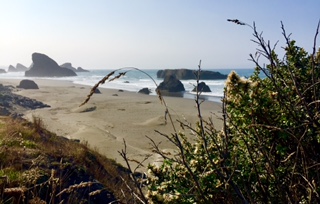
Harris Beach near Gold Beach Oregon.
We just meandered down PCH until we got to Harris Beach. Ton yelled stop at me so I swung into a pull out, and we spent the next hour walking up and down the beach. It is one of many spectacular stretches of nearly empty coast line. Ton took a bunch of pictures, and except for a haze that we think is from the wildfires in Napa California it was perfect.
Another view of Harris Beach.
As we worked our way down the coast towards Brookings, Ton yelled stop a couple of more times to take some more pictures, so there were a couple of shorter beach walks as we made our way south. We finally arrived in Brookings around 12:30 and started out towards the brewery that was our excuse for driving 80 miles.
Another view of Harris Beach.
Before we got there though Ton remembered a small hole in the wall seafood place she had read about. She said it was supposed to be good, fresh and simple seafood, so a quick reprogram of Greta Garmin and we were off. The food was as advertised, we split a seafood combo of 2 pieces of cod, 2 oysters, 4 pieces of calamari, 4 clams, and 4 shrimp, all fried. We substituted hush puppies for fries. The fish was all fresh and we enjoyed it.
The final stop in Brookings was at Chetco Brewing Company, which is our first Vegan Brewery. We are not sure what constitutes Vegan Brewing but we tried a taster of different styles of beer, and they were all pretty good. So I think I can say that this is the first Vegan food I have liked.
Battle Rock in Port Orford Oregon.
The return trip to Bandon was quick and the views were as spectacular going north as they were going south so we both enjoyed ourselves. We made one stop at Battle Rock park which marked the site where 9 white settlers were besieged on top of a rock by the natives who were not happy with the invasion of their land. It is now a pretty park in the town of Port Orford and we enjoyed our last walk for the day.
We had a leisurely start to the day. Once we got going we started south on PCH (Pacific Coast Highway). Our target today was my favorite town on the Oregon Coast. At one time I was an avid golfer and Bandon was my personal favorite golf course. Now that I am not golfing we visit a lot less.
This guy had dropped down from a tree and made this nest overnight. Almost hated to move Scout in the morning.
Enroute to Bandon thru the miracle of satellite technology we listened to two English soccer games as we were driving. Both games were shocking with Tottenham beating Manchester United 6-1 followed by Liverpool losing 7-2 to Aston Villa.
As we entered Coos Bay Ton remembered that there was a brewery there she really liked and asked if we could stop. I of course said ok and so we found ourselves sitting at 7 Devils brewery for a light lunch and a nice taster flight of their beers.
Today we are staying at an Oregon State Park. Oregon has a very large and well maintained park system. Oregonians tend to be outdoors people and they support the parks. When the pandemic hit, the parks were initially shut down completely. Over time they re-opened the parks, but now all campsites are only available thru reservation. We usually like to select our sites on the spur of the moment, but now we are having to plan a little more. I was startled when I went to make the reservation last night as there were only 6 spots available in a park with over 90 spots. We had read a lot of articles about people taking up camping as a way to have social distancing and recreation and I guess we are seeing the impact of that.
After checking in we headed over to Bandon which is a cute tourist oriented town. We walked around town again watching people crab and fish. They have three little fish restaurants on the waterfront, but they were all mobbed and the mask wearing and social distancing was poor so we moved on.
As we drove into town we saw a new cidery and decided to check it out. We had low expectations as neither one of us are big fans of cider. This place however, knocked our socks off. We tried a sample tray of 4 ciders and liked every one of them, so we decided to get a second sample tray of the remaining ciders and were equally impressed. If you are in town I really recommend Bandon Rain Cidery. Ton and I agreed on a favorite which is apple cider with gorse flowers.
The gulls were hoping for crab bits by the docks.
While we were at the cidery we decided to book our state park for tomorrow night. Our original plan was to follow the PCH from Astoria which is the northernmost town on the coast to Brookings which is the southernmost town. When I went to book a site the reservation system showed no availability in a park with 79 RV sites. I called to confirm and they said that the system was true. So we are going to drive down to Brookings tomorrow and return to Bandon for the night. When I went to book the state park here there were only 4 sites remaining for tomorrow out of 90!
Good Cider!The Coquille River looking towards Bandon Wildlife Refuge.
We finished by walking along the Coquille River to the ocean. It is a nice walk on the other side of the river is a Wildlife Refuge, though we did not see anything particularly interesting. We did not linger at the ocean as the wind was blowing pretty hard and kicking up the sand.
Neither one of us was in a big hurry to get going in the morning. We slept in a bit, then settled down to watch the Premier League game of the week with Paul and Khun Jim. Khun Jim cooked a big American breakfast to go with the game and we all enjoyed ourselves. Finally it was time to take off for our destination for the day.
The entire trip so far has been fogged in as you can tell from our photos. For the first time we did get a couple of sun breaks as we were driving over Cape Perpetua which is one of the more spectacular parts of the Pacific Coast Highway. Ton did not take any pictures though as while we were in the sun, the ocean was still pretty fogged in as the marine layer was just off shore.
We planned on staying at a Forest Service Campground near Florence, but as we were driving we began to get nervous because all of the State Parks and Forest Service campgrounds we saw had full signs posted at the entrances. We are still surprised how busy the coast is this week.
We made it into Sutton Creek Campground. A beautiful forested campground.
When we arrived at Sutton Campground we were relieved to find they had a few spots, so we grabbed one before heading into Florence to do some exploring. We have fond memories of Florence as it is the first place we ever took our kids on a vacation in Oregon. It is a cute fishing town that now is more tourist oriented than fishing oriented. The downtown is pretty compact consisting of only about 3 blocks of restaurants and stores. We picked a riverfront restaurant and shared some chowder and a salad that was pretty good. The highlight of the meal was watching a family on the dock below us crabbing. They were pulling in a number of crabs, but most were undersized and had to be tossed back much to the frustration of the 6 year old boy in the family.
I woke up early to take a walk along the ocean front, Ton had stayed up late catching up with one of her friends in Thailand on line. The surf was still pretty rough and the rock in front of the condo was taking a beating. The rock is usually covered with different sea birds, but this time there were only two birds on it. When I looked closely I realized that they were a pair of Bald Eagles which explained where all of the sea birds had gone.
A pair of bald eagles near our condo.
It was a pretty quiet day for us as we spent most of it catching up with our friends and watching the ocean crash on the rocks. We were hoping for a whale siting as the whales are migrating and this area is famous for whale watching. Despite a couple of whale watching boats going by we did not get to see any whales.
In the afternoon Ton and I drove back to Lincoln City to check out a brewery there. The beer was just ok and the setting was nice overlooking a golf course and a creek. The problem was it was a little chilly so we did not enjoy the setting as much as we would have liked.
After our beer taster we headed back to the condo for a nice dinner Khun Jim prepared, and an evening of watching old comedies on the TV.
We had a very good nights sleep at a very quiet and serene Camp Rilea. I got up for my morning stroll and met one of my neighbors who told me that a herd of elk usually came to feed on the grass on the rifle range behind the campsite. After spending a few minutes looking for the elk it looks like they decided to go somewhere else for breakfast this morning.
We got under way around 9am heading towards Depoe Bay. Good friends of ours Paul and Khun Jim are staying at a time share condo overlooking the ocean and we are going to spend the next couple of days with them.
We thought that October on the coast would be pretty quiet. Yesterday in Astoria seemed to confirm that idea, but today as we were driving south on the Pacific Coast Highway the traffic was extremely heavy with a lot of RV’s. One of the reasons became evident when we went thru the town of Garibaldi as the river was covered in fishing boats. One of the biggest salmon runs of the year is happening now so all of the fishermen are out trying to get their fish for the year. We stopped and watched the slow parade of fishing boats go by using their trolling motors.
The traffic continued to build as we headed south and we were really startled when one of the larger state parks had a full sign for the campground. It looks like our hope for a quiet off season week on the coast is not going to happen.
We arrived at Depoe Bay around noon and shifted into the luxury of the condo. Paul and I entertained ourselves talking and watching the surf crash on the rocks on the beach, while Ton and Khun Jim chatted at the kitchen table and planned the Thai meal for the evening.
When Paul turned in for a nap I headed to Depoe Bay for a cup of coffee and received final confirmation that the coast was not quiet but actually very busy. While I was gone Ton decided we needed to visit one of her favorite breweries which is near by so we were off to Wolf Tree Brewery in Lincoln City. The beer was as good as Ton remembered and after trying a sampler tray we decided to purchase a couple of cans of each beer on the tray.
We ended the day with a Thai fish meal prepared by a local restaurant with fish provided by Khun Jim. She convinced them to cook a couple of dishes not on the menu while we were gone sampling beer. Ton and Khun Jim were gone to the restaurant longer than Paul and I expected because as they explained when they returned the place was mobbed with customers and it took a while to get the special dishes done